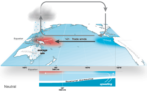
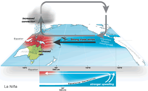
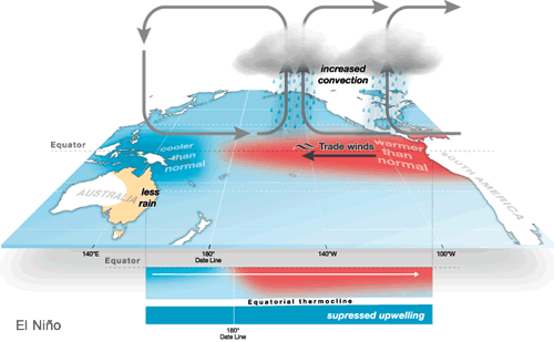
Australia’s weather is influenced by many climate drivers. Specifically, the El Niño-Southern Oscillation (ENSO) cycle has a strong influence on weather patterns on the East Coast of the country.
La Niña, one of three phases in the cycle, typically brings increased rainfall, cooler daytime temperatures, decreased frost risk, greater tropical cyclone numbers, and earlier monsoon onset. La Niña occurs when equatorial trade winds become stronger, changing ocean surface currents and drawing cooler deep water up from below. The warming of ocean temperatures in the western Pacific means the area becomes more favourable for rising air, cloud development, and rainfall. This cooler-than and wetter-than event generally lasts for several months in a row, and occurs every two to seven years.
El Niño, the opposite phase of La Niña, typically means reduced rainfall, warmer temperatures, increased frost, reduced tropical cyclone numbers, later monsoon onset, and increased fire danger. El Niño occurs when sea surface temperatures in the central and eastern tropical Pacific Ocean become substantially warmer than average, causing a shift in atmospheric circulation. These events are associated with a weakening of trade winds. Cooler water in the western Pacific Ocean has huge implications for rainfall, thus Australia experiences less evaporation, less condensation, and less rain.
The third phase of the ENSO cycle is neutral, whereby Australia is less likely to experience the extreme climate conditions of either La Niña or El Niño.
 |
 |
 |
Australia experienced three La Niña events in a row between 2020 and 2023. At current, Australia is sitting in the neutral phase of ENSO. However, it has been predicted that the country is in for an El Niño event this Summer.
Join us on our mission to love and serve people across Australia.
